
The phases in the linked chart are connected to the Statsbygg project model
Coverage
Hard terrain surfaces (hardscape) are considered as Coverage objects.
Modelling
For landscape modelling, it is important to view elevations and slopes in surfaces holistically. Today’s practice of modelling terrain as a cohesive surface (made possible by Civil3D and Novapoint) is important to compare elevations and slope angles. This cohesive surface could have been placed in bottom as a virtual object; comparable to the architect’s horizontal Level. However, the landscape architect’s Level is plastic and acts as the foundation for labeling elevations of all objects in the model.
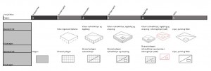
A coverage should be able to be modelled in three distinctive ways. Today, most landscape architects work with contour lines, the traditional approach when creating a 2D representation of 3D elevations. The second approach is through modelling of surfaces where elevations are defined by points, breaklines and slopes in between. The third approach is modelling in a more sculptural, freeform way similar to modelling with clay, or the modelling tools for terrain modifications in software such as Lumion. All of these methods are desired when working with coverage elevations.
Geometry through project stages
Leave a Reply